
Propuesta metodológica para el monitoreo de huellas vehiculares en comunidades vegetales protegidas del desierto
DOI:
https://doi.org/10.31055/1851.2372.v55.n2.25480Palabras clave:
Áreas protegidas, desierto, huellas vehiculares, impacto ambiental, vegetaciónResumen
Introducción y objetivos: El tránsito de vehículos sobre el terreno de áreas protegidas, constituye una amenaza al patrimonio natural que debe ser evaluada. El alto costo operativo de monitorear estas actividades hace que sea necesario desarrollar alternativas de evaluación rápidas y simples que permitan tener un primer parámetro de tendencias. Mediante freeware y técnicas básicas, se propone como caso de estudio evaluar las huellas vehiculares durante dos períodos (2004 y 2018) y su potencial impacto en la vegetación del área protegida Loma de Las Tapias, San Juan, Argentina.
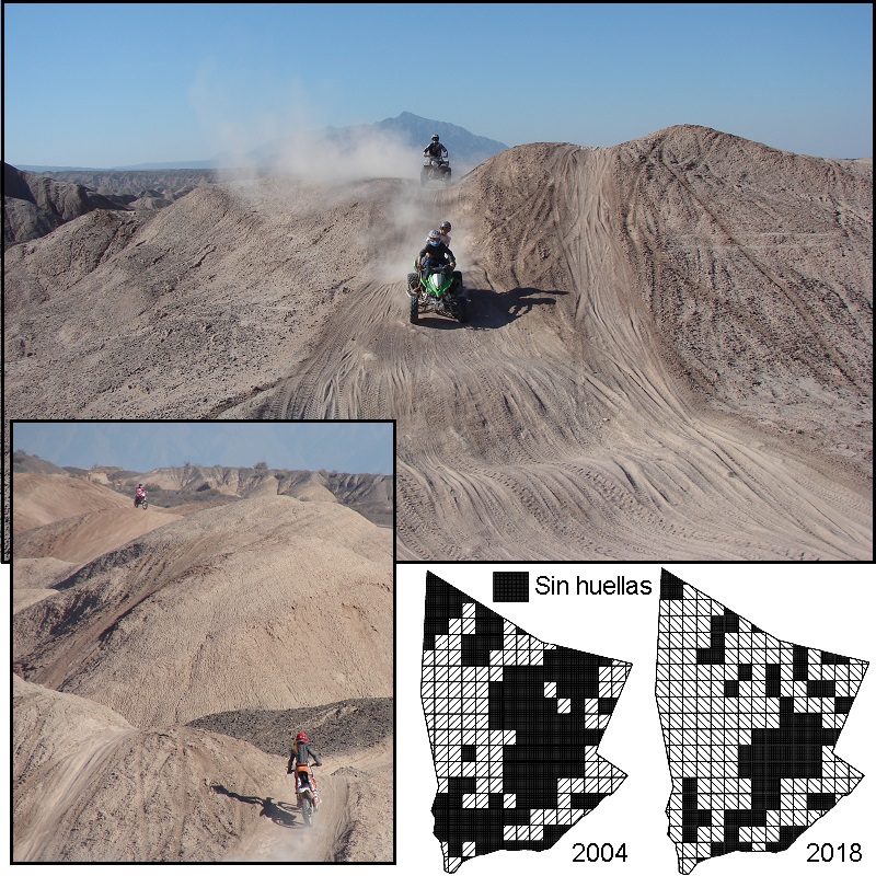
M&M: Empleando la zonificación florística preexistente y dos sets de imágenes satelitales (2004-2018), se cuantificaron las huellas vehiculares con una grilla, cuyos cuadros fueron categorizados según: ausencia de huellas; huellas antiguas (2004); huellas nuevas (2018) y huellas reincidentes (2004-2018) sobre las diferentes comunidades vegetales.
Resultados: Actualmente, de los 223 cuadros que constituyen la grilla, solo el 35 % no posee huellas vehiculares, mientras que el 13,9 % posee únicamente huellas antiguas, el 30 % huellas reincidentes y el 21,1 % restante posee huellas vehiculares nuevas. Por lo tanto, se observa un claro incremento de huellas durante el período evaluado, que fue uniforme en todas las unidades florísticas.
Conclusiones: La metodología propuesta resultó sencilla y rápida y permitió detectar el incremento de huellas en el área, estableciendo así valores de referencia para posteriores evaluaciones. El incremento de huellas observado, enfatiza la necesidad de priorizar la conservación y de incorporar nuevas capas temáticas para enriquecer la gestión del área protegida.
Referencias
ALMIRÓN, M. 2018. Vegetación del Monumento Natural y Paisaje Protegido Loma De Las Tapias. Departamentos Ullum y Albardón, San Juan (Argentina). B. Soc. Argent. Bot. 53: 385-403.
https://doi.org/10.31055/1851.2372.v53.n3.21313
BRATTON, S., M. HICKLER, & J. GRAVES. 1979. Trail erosion patterns in Great Smoky Mountains National Park. Environ. Manage. 3:431-445.
https://doi.org/10.1007/BF01866582
BROOKS, M., & B. LAIR. 2005. Ecological effects of vehicular routes in a desert ecosystem. Report prepared for the United States Geological Survey, Recoverability and Vulnerability of Desert Ecosystems Program (http://geography.wr.usgs.gov/mojave/rvde)
CABRERA, A. 1976. Regiones fitogeográficas argentinas. En: Enciclopedia argentina de agricultura y jardinería. Tomo 2. 2da edición. pp. 1-85. Ed. Kugler, W. Buenos Aires.
COLE, D., & N. BAYFIELD. 1993. Recreational trampling of vegetation: Standard experimental procedures. Biol. Conserv. 63: 209-215.
https://doi.org/10.1016/0006-3207(93)90714-C
CONTRERAS, V. & J. BARALDO. 2011. Calibration of the Chasicoan–Huayquerian stages boundary (Neogene), San Juan, western Argentina. En: Cenozoic Geology of the Central Andes of Argentina. Pp. 111-121. Ed. SCS Publisher. Salta, Argentina.
DUNIWAY, M., J. HERRICK, K. JASON & J. VAN ZEE. 2010. Assessing transportation infrastructure impacts on rangelands: Test of a standard rangeland assessment protocol. Rangeland Ecol. Manage. 63: 524-536.
https://doi.org/10.2111/REM-D-09-00176.1
GODOY-BÜRKI, A., P. ORTEGA-BAES, J. SAJAMA & L. AAGESEN. 2014. Conservation priorities in the Southern Central Andes: mismatch between endemism and diversity hotspots in the regional flora. Biodivers. & Conservation. 23: 81–107.
https://doi.org/10.1007/s10531-013-0586-1
GOOSSENS, D., B. BUCK & B. MCLAURIN. 2012. Contributions to atmospheric dust production of natural and anthropogenic emissions in a recreational area designated for off-road vehicular activity (Nellis Dunes, Nevada, USA). J. Arid Environ. 78: 80–99.
https://doi.org/10.1016/j.jaridenv.2011.10.015
GOOGLE EARTH PRO. 2019. Freeware imagery data-base. Versión 7.3. Disponible en: https://www.google.com/earth/
GRENKE, J., J. CAHILL, & E. BORK. 2018. Quantification of multi-use trail effects using a rangeland health monitoring approach and google earth. Nat. Areas J. 38: 370–379.
IVERSON, R. 1980. Processes of accelerated pluvial erosion on desert hillslopes modified by vehicular traffic. Earth Surf. Processes. 5: 369-388.
https://doi.org/10.3375/043.038.0506
KELLY, J. 2014. Effects of human activities (raking, scraping, off-road vehicles) and natural resource protections on the spatial distribution of beach vegetation and related shoreline features in New Jersey. J. Coast. Conserv. 18: 383–398.
https://doi.org/10.1002/esp.3760050407
KÖPPEN, W. 1931. Grundriss der Klimakunde. Ed. De Gruite, Berlin.
Ley Provincial Nº: 7307. (2002). Disponible en https://diputadossanjuan.gob.ar/leyes-sancionadas/item/2018-ley-n-7307.
NAVAS ROMERO, A., M. HERRERA MORATTA, A. DALMASSO & A. BARROS. 2019. Quad bike impacts on vegetation and soil physicochemical properties in an arid ecosystem. Acta Oecol. 97: 14–22.
https://doi.org/10.1016/j.actao.2019.04.007
Plantas endémicas de la Argentina. página web disponible en: www.lista-planear.org.
POBLETE, A. & J. MINETTI. 1999. Configuración espacial del clima de San Juan. Síntesis del Cuaternario de la Provincia de San Juan. 11º Reunión de Campo del Cuaternario. INGEO, Universidad Nacional de San Juan, San Juan.
Portal de noticias de la SEAyDS. Disponible en: https://sisanjuan.gob.ar/noticias-ambiente-y-desarrollo-sustentable
PSARALEXI, M., N. VOTSI, N. SELVA, A. MAZARIS, & J. PANTIS. 2017. Importance of roadless areas for the European Conservation Network. Front. Ecol. Evol. 5 (2).
https://doi.org/10.3389/fevo.2017.00002
QGIS, EQUIPO DE DESARROLLO. 2019. Sistema de información geográfica de código abierto. Fundación Fuente Geoespacial. Versión 3.4.2-Madeira. Disponible en: https://qgis.org/es/site/
RODRÍGUEZ, D. 2004. Estudio sedimentológico y estratigráfico del Neógeno superior de Loma de Las Tapias, con el fin de interpretar la evolución del antiguo río San Juan (Tesis de licenciatura, Universidad Nacional de San Juan).
SUVIRES, G. & V. CONTRERAS. 2011. Late Cenozoic geology and geomorphology of the Loma de Las Tapias area, San Juan, west central Argentina. En: Cenozoic Geology of the Central Andes of Argentina, pp. 427-436. Ed. SCS Publisher. Salta, Argentina.
Publicado
Número
Sección
Licencia
Derechos de autor 2020 Boletín de la Sociedad Argentina de Botánica

Esta obra está bajo una licencia internacional Creative Commons Atribución-NoComercial-SinDerivadas 4.0.
El Bol. Soc. Argent. Bot.:
- Provee ACCESO ABIERTO y gratuito inmediato a su contenido bajo el principio de que hacer disponible gratuitamente la investigación al público, lo cual fomenta un mayor intercambio de conocimiento global.

- Permite a los autores mantener sus derechos de autor sin restricciones.
- El material publicado en Bol. Soc. Argent. Bot. se distribuye bajo una licencia de Creative Commons Atribución-NoComercial-CompartirIgual 4.0 Internacional.


