Methodological proposal for monitoring of vehicular traces on protected plant communities of desert
DOI:
https://doi.org/10.31055/1851.2372.v55.n2.25480Keywords:
Protected areas, desert, vehicular traces, environmental impact, vegetationAbstract
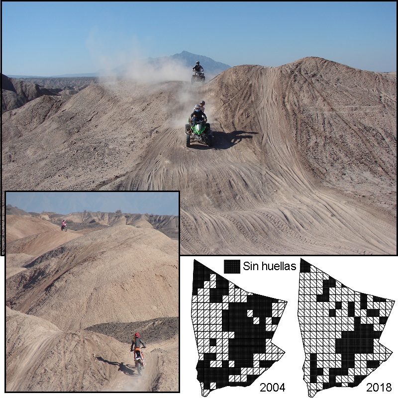
Background and Aims: The transit of vehicles within protected areas constitutes a threat to the natural heritage that must be evaluated. The high operational cost of monitoring these activities makes it necessary to develop quick and simple evaluation alternatives that allow having a first parameter of trends. Using freeware and basic techniques, I propose a study case to evaluate the increase in vehicle traces during two periods and their potential impact on the vegetation of the Loma de Las Tapias protected area, San Juan, Argentina.
M&M: Using pre-existing floristic zoning and two sets of satellite images (2004-2018), vehicle traces were quantified with a grid, and these squares were categorized according to: absence of traces; old traces (2004); new traces (2018) and relapsing traces (2004-2018) on the different floristic units. Results: Currently, from the 223 squares that constitute the grid, only 35 % showed no vehicular traces, while 13.9 % had only old ones, 30 % relapsing traces and the remaining 21.1 % had new vehicular traces. The increase during the evaluated period was uniform in all floristic units. Conclusions: The proposed methodology was simple and fast and allowed detecting the increase of vehicular traces in the area, establishing reference values for subsequent evaluations. The observed increase of traces emphasizes the need to focus on conservation efforts and to incorporate new thematic layers to enrich the management of the protected area.
References
ALMIRÓN, M. 2018. Vegetación del Monumento Natural y Paisaje Protegido Loma De Las Tapias. Departamentos Ullum y Albardón, San Juan (Argentina). B. Soc. Argent. Bot. 53: 385-403.
https://doi.org/10.31055/1851.2372.v53.n3.21313
BRATTON, S., M. HICKLER, & J. GRAVES. 1979. Trail erosion patterns in Great Smoky Mountains National Park. Environ. Manage. 3:431-445.
https://doi.org/10.1007/BF01866582
BROOKS, M., & B. LAIR. 2005. Ecological effects of vehicular routes in a desert ecosystem. Report prepared for the United States Geological Survey, Recoverability and Vulnerability of Desert Ecosystems Program (http://geography.wr.usgs.gov/mojave/rvde)
CABRERA, A. 1976. Regiones fitogeográficas argentinas. En: Enciclopedia argentina de agricultura y jardinería. Tomo 2. 2da edición. pp. 1-85. Ed. Kugler, W. Buenos Aires.
COLE, D., & N. BAYFIELD. 1993. Recreational trampling of vegetation: Standard experimental procedures. Biol. Conserv. 63: 209-215.
https://doi.org/10.1016/0006-3207(93)90714-C
CONTRERAS, V. & J. BARALDO. 2011. Calibration of the Chasicoan–Huayquerian stages boundary (Neogene), San Juan, western Argentina. En: Cenozoic Geology of the Central Andes of Argentina. Pp. 111-121. Ed. SCS Publisher. Salta, Argentina.
DUNIWAY, M., J. HERRICK, K. JASON & J. VAN ZEE. 2010. Assessing transportation infrastructure impacts on rangelands: Test of a standard rangeland assessment protocol. Rangeland Ecol. Manage. 63: 524-536.
https://doi.org/10.2111/REM-D-09-00176.1
GODOY-BÜRKI, A., P. ORTEGA-BAES, J. SAJAMA & L. AAGESEN. 2014. Conservation priorities in the Southern Central Andes: mismatch between endemism and diversity hotspots in the regional flora. Biodivers. & Conservation. 23: 81–107.
https://doi.org/10.1007/s10531-013-0586-1
GOOSSENS, D., B. BUCK & B. MCLAURIN. 2012. Contributions to atmospheric dust production of natural and anthropogenic emissions in a recreational area designated for off-road vehicular activity (Nellis Dunes, Nevada, USA). J. Arid Environ. 78: 80–99.
https://doi.org/10.1016/j.jaridenv.2011.10.015
GOOGLE EARTH PRO. 2019. Freeware imagery data-base. Versión 7.3. Disponible en: https://www.google.com/earth/
GRENKE, J., J. CAHILL, & E. BORK. 2018. Quantification of multi-use trail effects using a rangeland health monitoring approach and google earth. Nat. Areas J. 38: 370–379.
IVERSON, R. 1980. Processes of accelerated pluvial erosion on desert hillslopes modified by vehicular traffic. Earth Surf. Processes. 5: 369-388.
https://doi.org/10.3375/043.038.0506
KELLY, J. 2014. Effects of human activities (raking, scraping, off-road vehicles) and natural resource protections on the spatial distribution of beach vegetation and related shoreline features in New Jersey. J. Coast. Conserv. 18: 383–398.
https://doi.org/10.1002/esp.3760050407
KÖPPEN, W. 1931. Grundriss der Klimakunde. Ed. De Gruite, Berlin.
Ley Provincial Nº: 7307. (2002). Disponible en https://diputadossanjuan.gob.ar/leyes-sancionadas/item/2018-ley-n-7307.
NAVAS ROMERO, A., M. HERRERA MORATTA, A. DALMASSO & A. BARROS. 2019. Quad bike impacts on vegetation and soil physicochemical properties in an arid ecosystem. Acta Oecol. 97: 14–22.
https://doi.org/10.1016/j.actao.2019.04.007
Plantas endémicas de la Argentina. página web disponible en: www.lista-planear.org.
POBLETE, A. & J. MINETTI. 1999. Configuración espacial del clima de San Juan. Síntesis del Cuaternario de la Provincia de San Juan. 11º Reunión de Campo del Cuaternario. INGEO, Universidad Nacional de San Juan, San Juan.
Portal de noticias de la SEAyDS. Disponible en: https://sisanjuan.gob.ar/noticias-ambiente-y-desarrollo-sustentable
PSARALEXI, M., N. VOTSI, N. SELVA, A. MAZARIS, & J. PANTIS. 2017. Importance of roadless areas for the European Conservation Network. Front. Ecol. Evol. 5 (2).
https://doi.org/10.3389/fevo.2017.00002
QGIS, EQUIPO DE DESARROLLO. 2019. Sistema de información geográfica de código abierto. Fundación Fuente Geoespacial. Versión 3.4.2-Madeira. Disponible en: https://qgis.org/es/site/
RODRÍGUEZ, D. 2004. Estudio sedimentológico y estratigráfico del Neógeno superior de Loma de Las Tapias, con el fin de interpretar la evolución del antiguo río San Juan (Tesis de licenciatura, Universidad Nacional de San Juan).
SUVIRES, G. & V. CONTRERAS. 2011. Late Cenozoic geology and geomorphology of the Loma de Las Tapias area, San Juan, west central Argentina. En: Cenozoic Geology of the Central Andes of Argentina, pp. 427-436. Ed. SCS Publisher. Salta, Argentina.

Downloads
Published
Issue
Section
License
Copyright (c) 2020 Boletín de la Sociedad Argentina de Botánica

This work is licensed under a Creative Commons Attribution-NonCommercial-NoDerivatives 4.0 International License.
Provides immediate and free OPEN ACCESS to its content under the principle of making research freely available to the public, which fosters a greater exchange of global knowledge, allowing authors to maintain their copyright without restrictions.
Material published in Bol. Soc. Argent. Bot. is distributed under a Creative Commons Attribution-NonCommercial-ShareAlike 4.0 International license.


