Remote sensing techniques to identify and characterize forage communities in a livestock system in the hyper-arid desert of San Juan (Argentina)
DOI:
https://doi.org/10.31055/1851.2372.v55.n4.29322Keywords:
vegetation cover, natural grassland, remote sensing, drylandsAbstract
Background and aims: The natural grasslands of arid zones cover 40% of the earth's surface and are a valuable source of forage for livestock. Inappropriate management and high livestock loads are among the factors responsible for their degradation. In this sense, a fast evaluation is essential to correct its use and promote conservation. The objective of the study was to identify and characterize, through satellite image processing and fieldwork, forage plant communities in a rainfed livestock system of San Juan.
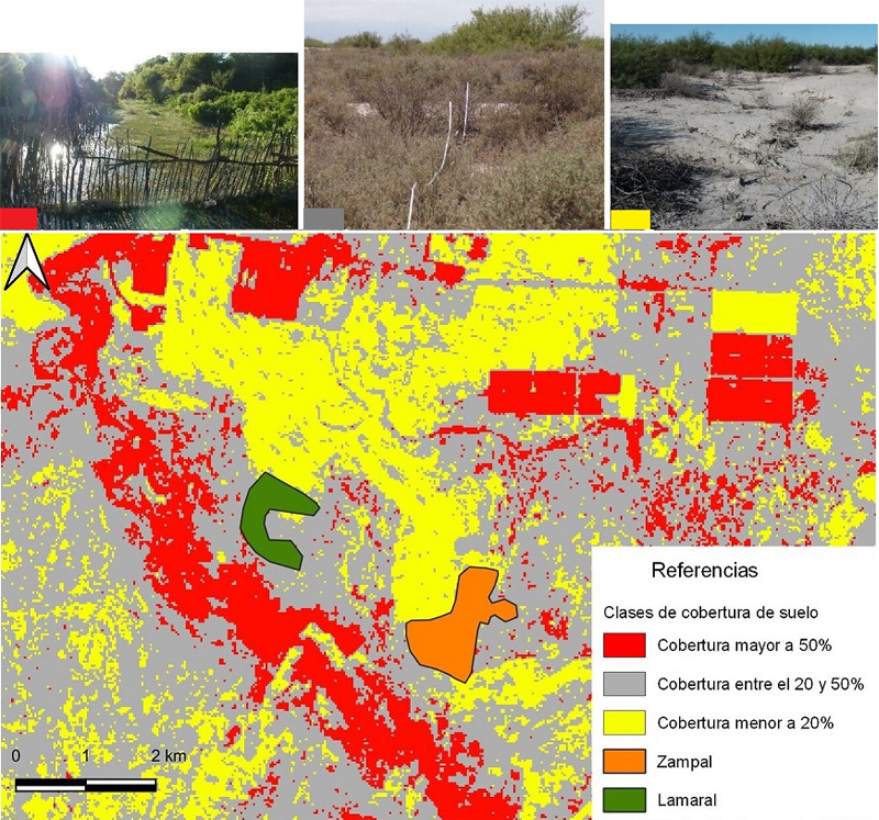
M&M: Indicator variables of soil and vegetation were generated from a Landsat 8 OLI image. Subsequently, unsupervised kmeans classification was performed. On field, plant cover, mulch and percentage of bare soil were registered from linear transects. Finally, the livestock receptivity of the plant communities was estimated.
Results: 3 types of coverage were identified: coverage higher than 50%; higher than 20% and less than 50% and less than 20%. Also, two forage communities were identified, Lamaral and Zampal. In Lamaral, Prosopis alpataco var lamaro obtained a coverage of 48%, a receptivity of 2.21 hectare/goat equivalent. In Zampal, a 35% coverage of Atriplex undulata was registered and the receptivity was 1.80 hectare/goat equivalent.
Conclusions: The digital processing carried out was adequate for the purpose of the study and allowed recognizing, characterizing and mapping two forage communities. The richness of the species was low, with a predominance of shrubs and woody plants, limiting livestock in the area.
Downloads
References
ADARVEZ, S., M. ONTIVEROS, S.M. GIANNONI, C. BORGHI & S. TORRELLA. 2016. Identificación y distribución de unidades ambientales en un área protegida (Ischigualasto) perteneciente a la región híper árida del desierto del monte. XVII Simposio Internacional SELPER.
BAIG, M.H.A., L. ZHANG, T. SHUAI & T. QINGXI. 2014. Derivation of a tasselled cap transformation based on Landsat 8 at-satellite reflectance. Rem. Sens. Letter 5: 423-431.
http://dx.doi.org/10.1080/2150704X.2014.915434
BERTILLER, M.B., A. BISIGATO, A. CARRERA, H.F. DEL VALLE. 2004. Estructura de la vegetación y funcionamiento de los ecosistemas del Monte Chubutense. Bol. Soc. Argent. Bot. 39: 139 - 158.
BISIGATO, A.J., P.E. VILLAGRA, J.O. ARES & B.E. ROSSI. 2009. Vegetation heterogeneity in Monte Desert ecosystems: A multi-scale approach linking patterns and processes. J. Arid Environ. 73: 182-191. https://doi.org/10.1016/j.jaridenv.2008.09.001
BLANCO, L. & F. BIURRUN. 2005. Niveles de degradación de la vegetación del Chaco árido. Una Aproximación cuantitativa a partir de imágenes satelitales. Serie de publicaciones del área de investigaciones del INTA 1-12pp. Ediciones INTA. Buenos Aires.
BLANCO, L., M. AGUILERA, M. PARUELO & F. BIURRUN. 2008. Grazing effect on NDVI across an aridity gradient in Argentina. J. Arid. Environ. 2: 764-776. https://doi.org/10.1016/j.jaridenv.2007.10.003
BLANCO, L., C. FERRENDO & F. BIURRUN. 2009. Remote Sensing of Spatial and Temporal Vegetation Patterns in Two Grazing Systems. Rangel. Ecol. Managem. 62:445-451. https://doi.org/10.2111/08-213.1
BREGAGLIO, M., U. KARLIN & R. COIRINI. 1999. Respuesta de especies arbustivas forrajeras a tratamientos de desmonte selectivo en el Chaco Árido, Argentina. Multequina 8: 101-109.
CABIDO, A. L., A. MANZUR, L. CARRANZA & C. GONZALEZ ALBARRACIN.1 994. La vegetación y el medio físico del Chaco Árido en la provincia de Córdoba, Argentina Central. Phytocoenologıa 24:423-460. https://doi10.1127/phyto/24/1994/423
CAMPOS, V.E., M.G. GATICA, F. CAPPA, S. GIANNONIA & C. CAMPOS. 2018. Remote sensing data to assess compositional and structural indicators in dry Woodland. Ecol. Indicators 88: 63-70. https://doi.org/10.1016/j.ecolind.2018.01.032
CONEGLIANO, O. 2018. Comportamiento en pastoreo del ganado bovino criollo argentino y aberdeen angus ecotipo riojano, en pastizales naturales del Chaco Árido. Tesis de Maestría. Universidad Nacional de Mar de Plata, Argentina.
CONGALTON, R. G. 1991. A review of assessing the accuracy of classifications of remotely sensed data. Remote Sensing Environm. 37: 35-46. https://doi.org/10.1016/0034-4257(91)90048-B
CONGALTON, R.G., K. GREEN. 1999. Assessing the accuracy of remotely sensed data: principles and practices. 3ra ed. Boca Raton, Minnesota.
CZAPLA-MYERS, J., J. MCCORKEL, N. ANDERSON, K. THOME, S. BIGGAR, D. HELDER, D. ARON, L. LEIGH & N. MISHRA. 2015. The Ground-Based Absolute Radiometric Calibration of Landsat 8 OLI. Remote Sensing 7: 600-626. https://doi.org/10.3390/rs70100600
CHANDER, G., B. MARKHAM & D. HELDER. 2009. Summary of current radiometric calibration coefficients for Landsat MSS, TM, ETM+ and EO-1 ALI sensors. Remote Sensing Environm. 113: 893-903. https://doi.org/10.1016/j.rse.2009.01.007
CHUVIECO, E. 2006. Teledetección Ambiental. La observación de la Tierra desde el Espacio. 2ª edición. Editorial Ariel S.A. Barcelona. España.
DALMASSO, A., J. MÁRQUEZ, A.L. NAVAS, M.A. MORATTA, L. GORDILLO & E. SALOMÓN. 2018. Las Principales pasturas del secano cuyano. Ediciones UNSJ, San Juan.
GOIRÁN, S.B., J.N. ARANIBAR & M.L. GOMEZ. 2012. Heterogeneous spatial distribution of traditional livestock settlements and their effects on vegetation cover in arid groundwater coupled ecosystems in the Monte Desert Argentina. J. Arid Environm. 87: 188-197. https://doi.org/10.1016/j.jaridenv.2012.07.011
GOLLUSCIO, R., H. BOTTARO, D. RODANO, M.F. GARBULSKY, S. BOBADILLA, O. BURATOVICH & M. VILLA. 2009. Divergencias en la estimación de receptividad ganadera en el noreste de la Patagonia: diferencias conceptuales y consecuencias prácticas. Ecol. Austral. 19:3-18
KARLIN, M. S., E. V. BUFFA, U. KARLIN, M.A. CONTRERAS, R. COIRINI & E.J.RUIZ POSSE. 2012. Relaciones entre propiedades de suelo, comunidades vegetales y receptividad ganadera en ambientes salinos (Salinas Grandes, Catamarca, Argentina). Revista Latinoamericana de Recursos Naturales 8: 30-45.
KAUTH, R. J. & G.S. THOMAS. 1976. The tasseled cap a graphic description of the spectral temporal development of agricultural crops as seen in Landsat. In: Proceedings on the Symposium on Machine Processing of Remotely Sensed Data. Purdue, pp. 41-51.
MALDONADO, F., V. CARVALHO, C. DE SOUS, M. MARTINELLI, J. PINHEIRO & F. FERNANDES DO SANTOS. 2004. Determinación de la longitud de transecta para el relevamiento fisonómico estructural del semiárido para suministrar datos a las técnicas de percepción remota orbital. Multequina 13:01-14.
MÁRQUEZ, J., E. MARTÍNEZ CARRETERO, A. DALMASSO, G. PASTRÁN & G. ORTIZ. 2005. Las áreas protegidas de la provincia de San Juan (Argentina) II. La vegetación del Parque Provincial de Ischigualasto. Multequina 14: 1-27.
MARTINELLI, M. & E. MARTÍNEZ CARRETERO. 2014. Matorrales forrajeros en zonas áridas: indicadores de estado. Multequina 23: 29-40.
MARTINELLI, M. 2009. Caracterización de la degradación de tierras en sistemas productivos de zonas áridas, en Valle Fértil, noreste de San Juan, Argentina. Identificación de indicadores. Tesis Doctoral. Universidad Nacional de Río Cuarto. Córdoba.
MARTINELLI, M., J. CARMONA CROCCO, R. TAPIA & M. GAVIORNO. 2017. Comunidades forrajeras del Monte: aportes para pensar el manejo de la ganadería integrada en el bosque árido de San Juan (Argentina). 1º Encuentro nacional sobre periurbanos e interfases críticas, 2ª Reunión científica del PNNAT, Córdoba. Argentina.
MIRANDA, O. 2015. El riego en la provincia de San Juan, Argentina: su dinámica institucional en los últimos dos siglos. Agricultura, sociedad y desarrollo 12: 385-408.
MOSTACEDO, B. & T. FREDERICKSEN. 2000. Manual de método básico de muestreo y análisis en ecología vegetal. El País, Santa Cruz de la Sierra.
PARUELO, J. 2008. La caracterización funcional de ecosistemas mediante sensores remotos. Ecosistemas. 17:4-22.
PASSERA, C., A. DALMASSO & O. BORSETTO. 1983. Método de Point Quadrat modificado. Taller sobre arbustos forrajeros de zonas árida y semiárida 135-152.
POBLETE, A. & J. MINETTI. 1999. Configuración espacial del clima de San Juan. Síntesis del Cuaternario de la Provincia de San Juan. 11º Reunión de Campo del Cuaternario. INGEO, Universidad Nacional de San Juan, San Juan.
QGIS, EQUIPO DE DESARROLLO. 2017. Sistema de información geográfica de código abierto. Fundación Fuente Geoespacial. Versión 2.18.20. Disponible en: https://qgis.org/es/site
REYNOLDS, J. & D.M. STAFFORD SMITH. 2002. Do humans cause deserts?. Dahlem Workshop Report 88. Berlin.
RICHARDS, J. & X. JIA. 2006. Remote Sensing Digital Image Analysis. 4ta ed. Springer-Verlag, Berlin.
ROSENFIELD, G. H. & K. FITZPATRICK-LINS. 1986. A coefficient of agreement as a measure of thematic classification accuracy. Remote Sensing 52: 223- 227.
SAGA GIS. 2017. System for Automated Geoscientific Analyses. Versión 2.3.2. Disponible en: http://www.saga-gis.org/en/index.html
SALA, O. & J. PARUELO. 1997. Ecosystem services in grasslands. In: G. DAILY (ed). Nature´s Services: Societal dependence on natural ecosystems, pp. 237-252 Island Press, California. EE.UU.
SCAGLIA, J., J. CARNINO & C. MEGLIOLI. 2018. Evaluación de pastizales en áreas degradadas de la localidad de Las Trancas - 25 de Mayo -San Juan. VIII Congreso Nacional y IV Congreso del Mercosur de Pastizales Naturales. La Rioja. Argentina.
SUVIRES, G. & P. LUNA. 2008. Unidades geomorfológicas ambientales del sur del oasis del Tulum, Andes Centrales de Argentina. Multequina 17: 109-128.
VERA, G., L. BLANCO. & C.A. FERRANDO. 2003. Relaciones entre la pobreza rural y el deterioro de los recursos forrajeros por prácticas ganaderas comunitarias en los Llanos de La Rioja. Ediciones INTA, Buenos Aires.
VILLAGRA, P., C. GIORDANO, J. ALVAREZ, J. CAVAGNARO, A. GUEVARA, C. SARTOR, C. PASSERA & S. GRECO. 2011. Ser planta en el desierto: estrategias de uso de agua y resistencia al estrés hídrico en el Monte Central de Argentina. Ecol. Austral 21: 29-42.
ZAMBRANO, J.J. & G. SUVIRES. 1987. La estructura superficial y profunda en el valle de Tulum, provincia de San Juan. X Cong. Geol. Arg. TI. San Miguel de Tucumán. pp:11-19.
ZERDA, R. & J. TIEDEMANN. 2010. Dinámica temporal del NDVI del bosque y pastizal natural en el Chaco Seco de la Provincia de Santiago del Estero, Argentina. Revista Ambiência 6: 13-24.
Published
How to Cite
Issue
Section
License
Copyright (c) 2020 Raúl E. Tapia, Julieta Carmona Crocco, Mariana Martinelli

This work is licensed under a Creative Commons Attribution-NonCommercial-NoDerivatives 4.0 International License.
Provides immediate and free OPEN ACCESS to its content under the principle of making research freely available to the public, which fosters a greater exchange of global knowledge, allowing authors to maintain their copyright without restrictions.
Material published in Bol. Soc. Argent. Bot. is distributed under a Creative Commons Attribution-NonCommercial-ShareAlike 4.0 International license.